Some links in my articles are affiliate links. I may earn a commission when you buy through them.
For a first score-orienteering event, plan a small loop you understand, identify where you can shorten it and keep checking how long it will take to finish. A tempting extra control earns little if the detour costs more points in late penalties—or takes you onto ground you cannot navigate confidently.
Score events let you choose which controls to visit, subject to the event’s rules. The calculations here are hypothetical examples, not a suggested safety margin or the scoring rules for every competition.
Bristol Orienteering Klub distinguishes line courses, with controls visited in sequence, from score courses, where you select controls and their order. Southdowns Orienteers describes its score format as collecting controls within a time limit. Individual events may add restrictions, bonuses or different time allowances.
Before starting, find the time allowance, each control’s value, any required sequence and the late-return rule. Check whether a penalty applies to each minute or part-minute, whether lateness eventually cancels the result, and how equal scores are separated. If the instructions do not say, ask before planning around an assumed rule.
Do not infer points from a control number unless the instructions tell you to. Likewise, a control that looks close on the map can be expensive to reach if the permitted approach involves a crossing or a long way around.
Build a loop with an early way home
Start by locating the finish, the allowed crossings and any out-of-bounds areas. Choose a few controls linked by routes you can recognise, then identify a point where you can return without committing to the rest of the loop. Use that as a decision point when you see how the navigation is going.
Estimate the whole route you will use, including the return, rather than adding straight lines between circles. Include time for reading the map, checking a control and crossing roads where permitted. Base estimates on similar ground and your navigation experience; road-running pace is a poor substitute for time spent finding a small feature.
A compact loop close to the finish can be a better first plan than chasing the farthest high-value control. You can spend your attention on navigation and still have a useful shorter option if a leg takes longer than expected. Respect boundaries and use permitted crossings when shortening the route.
Compare a detour with the points it could lose
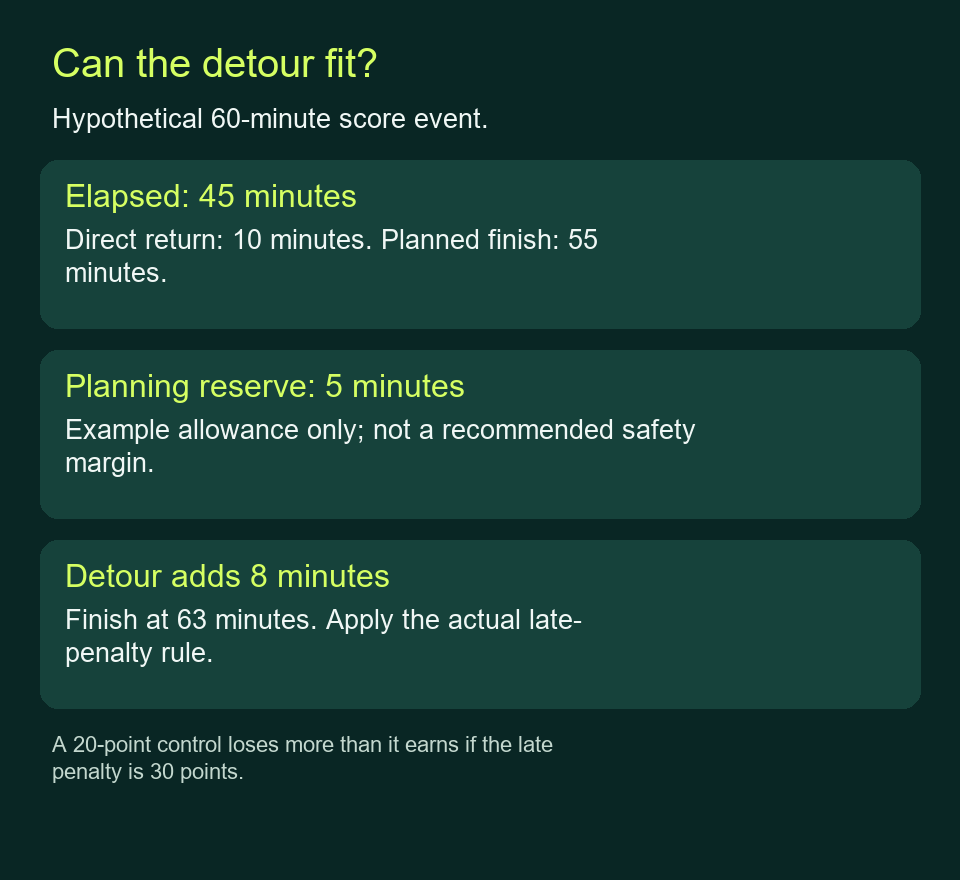
Suppose a fictional event allows 60 minutes and deducts 10 points for each minute or part-minute late. At 45 minutes, you estimate 10 minutes to finish by your intended route. That puts you back at 55 minutes, leaving a five-minute planning reserve.
Now consider a 20-point control that adds eight minutes to that same route:
Hypothetical choice
Estimated finish
Penalty under the example rule
Change in score
Return directly
55 minutes
None
Keep your current points.
Add the eight-minute detour
63 minutes
30 points
Gain 20, lose 30: net 10 points worse.
This comparison assumes the control is found and every time estimate is correct. If the event instead penalised five points per late minute, the same 63-minute finish would lose 15 points and gain a net five. Neither rate is a rule for DVO or for score orienteering generally.
Read a part-minute rule carefully. Under the fictional ten-point rule, arriving 61 minutes and one second after the start attracts two minutes of penalty, not one. Do not plan to use every last second: a missed junction can overturn a marginal points calculation.
Hypothetical 60-minute event. The reserve and penalty rate illustrate the arithmetic; choose your plan from the actual course and conditions.
Update the return estimate while you are out
At a recognisable junction or completed control, compare elapsed time with your plan. If two early legs took longer than expected, revise the remaining legs too. Spending the reserve to keep the original control list removes the option you deliberately built in.
Ask “How long from here to the finish by a route I can use?” before asking which control is nearest. The next control may lead away from an easy return, or leave a difficult last leg. Give yourself permission to finish with unvisited controls.
Points do not justify trespassing, unsafe crossings or continuing beyond your navigation ability. If you stop competing or cannot complete the plan, use the organiser’s return and reporting instructions. Check the actual finish location rather than assuming your parked car is where you must report.
An actual example: DVO’s Winter MapRuns 2026
The DVO series instructions describe hour-long score sessions with up to 35 controls, a choice of order and penalties for returning late. They direct runners to the map for the penalty details, and flag special scoring for Chaddesden and Mackworth. A single series-wide penalty rate is not established by that page.
For Spondon on 9 November 2026, the linked listing gives registration at 18:45 and a 19:00 night start. The series uses a phone-based mass start, with the map available in the app ten minutes beforehand. If you print a map in advance, use the exact round’s version and read its scoring notes.
DVO says there are no physical markers at the control sites: phone GPS confirms visits with a beep. Its instructions ask you to confirm the finish after the finish beep, and to ignore that prompt if you merely pass through the finish during the run. Learn the app procedure before relying on it in the dark; ask the event helpers to resolve a missing confirmation.
The club requests a charged phone with the course loaded and suitable high-visibility clothing for its roads and parks. Check the exact event’s current access and kit instructions too. This example describes this series; it does not establish that phones are permitted for navigation in other forms of racing.
Make the next outing easier to plan
Afterwards, compare your planned legs with the time they actually took. Separate time lost through route choice, map reading and finding the control from time spent moving. A slower but obvious path can be worth choosing again if it makes your estimate more reliable.
Pick one thing to practise next time, such as recognising junctions promptly or choosing a return point earlier. If reading the map was the main difficulty, seek a supported daytime course or club coaching before adding distance or darkness.